NOTICE OF PUBLIC HEARING
AND SUMMARY OF PROPOSED ORDINANCE
TAKE NOTICE that the Mayor and Nezperce City Council intend to adopt Nezperce City
Ordinance No. _, providing for annexation of certain parcels of real property to the
City of Nezperce and zoning of the annexed parcels.
TAKE FURTHER NOTICE that a public hearing before the Nezperce City Council pursuant
to Idaho Code § 67‐6509 to consider adoption of said ordinance shall be held at the following
date, time and place:
Date: ____July 25, 2022_________________
Time: _7:00__PM
Place: City Council Chambers Nezperce City Hall 606 Maple St Nezperce, ID 83543 Pursuant to Idaho Code § 67‐6509, a summary of the proposed ordinance is provided as follows: Name of City: City of Nezperce, Lewis County, Idaho. Identification of Ordinance: Nezperce City Ordinance No. _.
Descriptive Title: None.
Summary of Principal Provisions of Ordinance: The following is a summary of the
principal provisions of the proposed ordinance:
RECITALS: Providing recitals, findings and a statement of authority.
SECTION 1: Annexing those certain parcels of real property more particularly described
in Exhibit 1 attached to this notice to the City of Nezperce.
SECTION 2: Providing for zoning and designating the zoning district classification of the
following parcels within the annexed real property, as follows:
2022-5
July 25, 2022
7:00 PM
2022-5
NOTICE OF PUBLIC HEARING AND SUMMARY OF PROPOSED ORDINANCE ‐ 2
PARCEL: ZONING/ZONING DISTRICT:
Payne Parcels 1, 2 and 3 Zone D – Industrial;
School Parcel Zone D – Industrial;
Airport Parcel Airport Zone; and
Lagoon Parcel Zone D – Industrial.
SECTION 3: Providing for amendment of the City of Nezperce Zoning Map to include
the annexed real property.
SECTION 4: Providing for recording of this ordinance and notice of this ordinance to
governmental entities.
SECTION 5: Providing that the ordinance is severable.
SECTION 6: Providing for repeal of conflicting ordinances.
SECTION 7: Providing that the ordinance shall be effective upon its adoption and
publication as provided by law.
A copy of the full text of the proposed ordinance may be obtained from Nezperce City
Clerk, at the Nezperce City Hall, 606 Maple St, Nezperce, ID 83543.
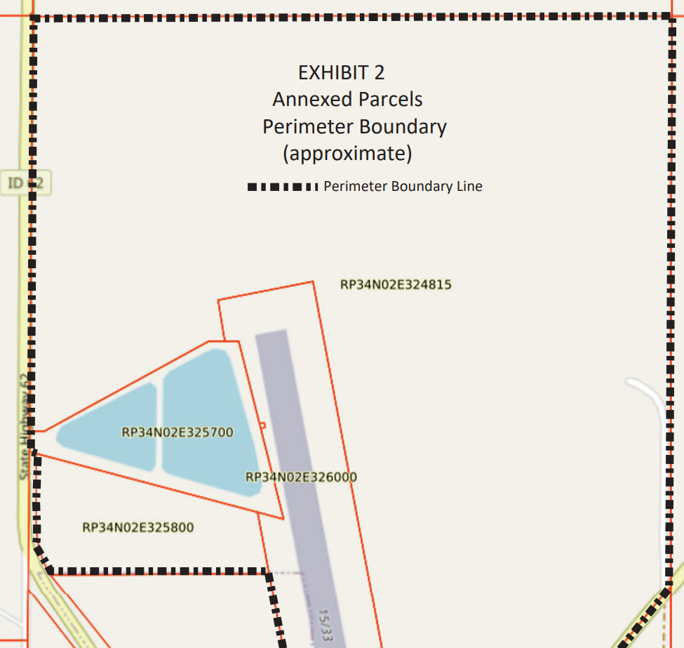
A drawing generally depicting the perimeter boundary of the proposed annexed real
property is attached to this notice as Exhibit 2.
CITY OF NEZPERCE
Date: ____ By:___________________
Rhonda J. Schmidt
City Clerk
6/29/2022 /S/
EXHIBIT 1
Annexed Parcels
(Perimeter Boundary Description)
That portion of the SW1/4 of Section 32, Township 34 North, Range 2 East, B.M., Lewis County,
Idaho, more particularly described as follows:
COMMENCING at the W1/4 corner of said Section 32, thence North 89°58’18” East along the
north boundary of said SW1/4, 68.00 feet, more or less, to the east right‐of‐way line of State
Highway 62, said point being the POINT OF BEGINNING;
thence continuing North 89°58’18” East along said north boundary, 2,579.66 feet, more or less,
to the northeast corner of said SW1/4;
thence South 00°04’03” East 2,317.71 feet, more or less, to the northwesterly right‐of‐way line
of State Highway 64;
thence South 40°28’17” West along said northwesterly right‐of‐way line, 430.43 feet, more or
less, to the south boundary of said Section 32;
thence North 89°59’38” West along said south boundary 1,298.28 feet, more or less, to the
existing City of Nezperce City Boundary;
thence North 10°44’45” West, along said boundary, 387.47 feet, more or less, to angle point in
said City Boundary;
thence North 89°59’38” West, along said City Boundary, 908.50 feet, more or less, to the easterly
right‐of‐way line of said Highway 62;
thence continuing along said easterly right‐of‐way line 410.00 feet along the arc of a non‐tangent
curve to the right, said curve having a radius of 410.00 feet, a central angle of 30°35’48”, and a
long chord which bears North 15°06’40” West a chord distance of 216.35 feet;
thence continuing along said easterly right‐of‐way line North 00°20’46” East 1333.65 feet;
thence continuing along said easterly right‐of‐way line North 06°03’24” East 100.50 feet;
thence continuing along said easterly right‐of‐way line North 00°20’46” East 500.00 feet;
thence continuing along said easterly right‐of‐way line North 06°03’24” East 100.50 feet;
thence continuing along said easterly right‐of‐way
line North 00°20’46” East 20.6 feet, more or less, to the POINT OF BEGINNING.
[END OF DESCRIPTION]